Is Malaysia really quake-free? Why Johor was rattled by a rare 4.1-magnitude tremor
MetMalaysia confirmed that a 4.1-magnitude earthquake struck Segamat at 6.13am, followed by a 2.8-magnitude tremor in Kluang at 9am on August 24, 2025. — Picture from Facebook/Malaysian Meteorological Department
Monday, 25 Aug 2025 1:05 PM MYT
KUALA LUMPUR, Aug 25 — Malaysia is typically not associated with earthquakes, thanks to its geographic location and geological makeup.
However, such natural phenomena aren’t too rare as the country has often felt tremors due to earthquakes recorded in nearby countries like Indonesia.
While some may perceive Malaysia as a quake-free country, Johor experienced a rare quake yesterday, which caused no significant damage or injuries.
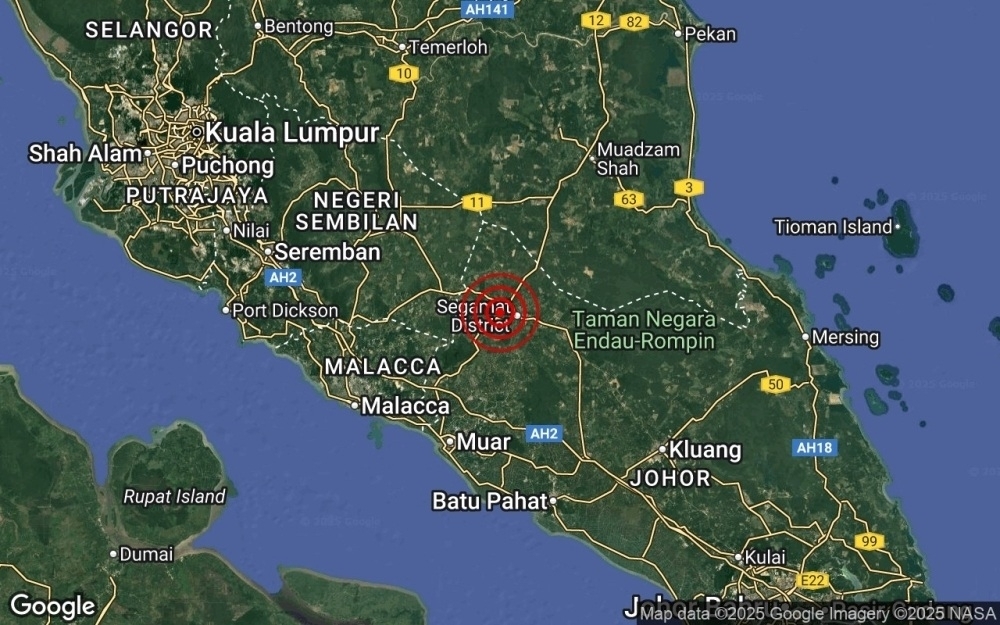
The Malaysian Meteorological Department reported a 4.1-magnitude quake at 6.13am, with the epicentre 5km west of Segamat at a depth of 10km.
The tremor was felt across several states, including Johor, Negeri Sembilan, Melaka and southern Pahang.
A second, milder tremor with a magnitude of 2.8 hit the same regions at 9am, centred 28km north-west of Kluang, Johor.
For decades, experts have considered Malaysia a low seismic risk, with the majority of tremors being minor and rarely causing significant damage.
While Malaysia’s geological setting is generally stable, there have been notable exceptions in the past that marked devastating seismic moments for the country.
Is Malaysia quake-free?
Despite its quake-free reputation, Malaysia does experience occasional tremors due to the presence of minor fault lines and geological features within its borders.
Unlike regions situated along the Pacific Ring of Fire — a tectonic belt of volcanoes and earthquakes that surrounds most of the Pacific Ocean — Malaysia lies on the relatively stable Sunda Shelf.
However, according to the Journal of Asian Earth Sciences 2019, the country’s geological makeup includes several fault lines and fault zones that can generate minor earthquakes when stressed.
These faults are leftovers of ancient geological activity and are capable of producing tremors, especially in areas like Sabah, Sarawak, and parts of Peninsular Malaysia, which occasionally register small-scale quakes.
While large-scale, destructive earthquakes are rare, the existence of these minor faults means that the country is not entirely exempt from seismic activity.
To better understand our seismic history, here's a look at some of the most significant earthquakes that occurred in the past:
Sabah Earthquake, June 5, 2015
The 2015 Sabah earthquake struck Ranau, Sabah, Malaysia, with a magnitude of 6.0 near Mount Kinabalu, which lasted for 30 seconds.
The devastating event led to 18 deaths and caused widespread damage to the surrounding area and led to the mountain being closed to climbers until September 1, 2015.
Sabah Earthquake, July 26, 1976
The 1976 Sabah earthquake occurred near Lahad Datu in the eastern portion of Sabah, with a magnitude of 6.3, one of the strongest earthquakes in Malaysia ever recorded by seismic instruments.
The quake, however, reportedly caused less extensive damage compared to the 2015 event.
Sarawak Earthquake, October 1, 2015
One of the strongest earthquakes near Sarawak in the past decade occurred on October 1, 2015, with a magnitude of 5.2 and struck 243km north-west of Miri, at a depth of 10km.
Pitas Earthquake, Sabah, March 28, 2022
A weak earthquake measuring 3.8 magnitude struck Beluran, Sabah, on March 28, 2022, with a depth of 7km, and occurred about 47km east of Pitas.
Janda Baik Earthquake, Pahang, December 5, 2009
A rare but weak earthquake with a magnitude of 2.2 struck Janda Baik in Bukit Tinggi on December 5, 2009, with the epicentre 9km south-east of Kg Janda Baik.
Understanding earthquake magnitudes:
Earthquake magnitudes are measured on the Richter scale, ranging from one to nine, and they indicate the energy released by a quake. Here’s a quick overview:
- Magnitude 1-2: Usually imperceptible, felt only by instruments, and often leaves no damage.
- Magnitude 3-4: Often felt by people nearby; minor tremors with little to no damage.
- Magnitude 5-6: Felt more widely; can cause minor to moderate damage, particularly to poorly constructed buildings.
- Magnitude 7: Considered major; capable of causing serious damage over large areas.
- Magnitude 8 and above: Rare but catastrophic; can cause massive destruction, including widespread building collapse, trigger a tsunami and also be fatal.
Recommended reading:
After Segamat, 2.8-magnitude quake jolts Kluang, Communications Ministry mulls disaster alert system
No comments:
Post a Comment