Monday, May 4, 2026
“Fortify Andamans Now”: Ex-Admiral Warns Malacca Strait Could Become the Next Hormuz — India Must Play Its Trump Card
By ET Columnist
By Rear Admiral (R) Girish Kumar Garg
Is the Malacca Strait the next Strait of Hormuz?
The Strait of Malacca is as crucial to the world economy as the Strait of Hormuz, as over 40% of global trade and approximately 25% of the world’s traded oil passes through it. If the Strait of Hormuz is 33 Kms wide at its narrowest point, the Malacca Strait is just 2.7 kms. It is a critical lifeline for East Asia.
China’s ‘Malacca Dilemma’ has been well-known for decades. Whilst it may have been considered theoretical until now, it suddenly looks feasible, especially after Indonesia’s rant about levying tolls on traffic in the Strait of Malacca.
If the world community suddenly feels threatened of being choked in the Malacca Strait, their apprehensions are not unfounded, looking at the history of Indonesia having suspended traffic in the Sunda and Lombok Straits in the past, to assert its maritime sovereignty over these Straits, just as Iran is doing in the Strait of Hormuz.
The fact that the Strait of Malacca has three coastal states as stakeholders (Singapore, Malaysia, and Indonesia) offers little consolation, since the Strait of Hormuz similarly has three states (Iran, Oman, and the UAE).
Critically, the Malacca Strait not only provides transit to merchant traffic but also to military warships transiting between the Pacific and the Indian Ocean. As security concerns about the Strait of Malacca gain traction, the world would look for a security architecture around the Strait to safeguard its shipping.
Andaman and Nicobar Islands
India’s Andaman and Nicobar Islands (ANI), located barely 350 km from the Strait of Malacca, provide India with a geostrategic lever. From the southern tip of Great Nicobar Island, India can easily monitor and, if necessary, provide security cover for traffic in the Strait of Malacca, provided we have the wherewithal in the ANI, which, unfortunately, we currently do not have.
Moreover, in the event of hostilities with China, ANI can serve as a launchpad for interdicting Chinese merchant and military traffic transiting through the Strait of Malacca.
Also, the Indo-Pacific, which the Strait of Malacca connects, is no longer a geographical construct. It is the center of gravity in global geopolitics. Stretching from the east coast of Africa to the western shores of the United States, it is where the balance of power in the 21st century will be decided. The Malacca Strait is therefore critical to the entire Indo-Pacific as a construct. In this likely geopolitical milieu, the Andaman and Nicobar Islands can be India’s strategic fulcrum.
However, India’s strategic posture in the Andaman & Nicobar Islands is alarmingly insufficient. The Andaman and Nicobar Command—India’s only integrated tri-service command—was established in 2001 with great promise. But over two decades later, it remains grossly under-resourced and far from combat-ready.
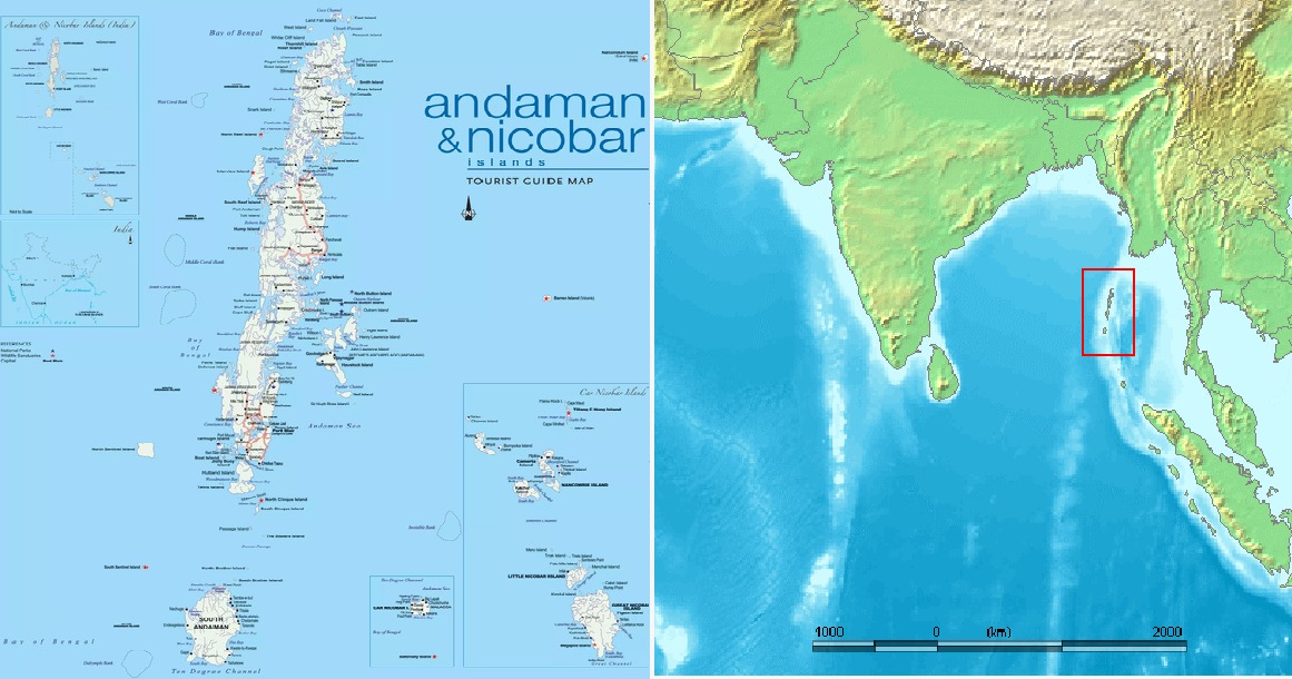
Andaman and Nicobar Islands.
Critical military infrastructure, such as deep-sea Naval Bases, long runways, drone bases, long-range surveillance radar chains, and electronic surveillance measures, is either absent or grossly inadequate.
The vulnerability quotient of these islands is very high, as they are a short detour from the inimical military vessels transiting the Malacca Strait and utilizing ‘innocent passage’ through the Six Degree Channel or the Ten Degree Channel. Forget about projecting power in the Malacca Strait or the Indo-Pacific; should a border skirmish like Doklam happen on any of the 572 mostly uninhabited islands of the Andaman & Nicobar, the military capabilities on these islands would be woefully inadequate even to deter it. By the time the reinforcements arrive from mainland India, 1400 kms away, enough strategic and reputational damage would have been caused.
Meanwhile, the world around these islands is posturing for the eventuality. China is steadily expanding its military footprint—from fortifying reclaimed islands in the South China Sea, to investing in dual-use port facilities in Myanmar, and deploying submarines and surface vessels in the Indian Ocean under the banner of counter-piracy operations.
Chinese naval vessels, including nuclear-powered submarines, are increasingly active in India’s maritime backyard, including the Andaman Sea. China has militarily developed the Coco Islands in Myanmar, located just 45 km north of the islands, with an airstrip, Signals Intelligence, and electronic surveillance facilities.
With an eye on the Strait of Malacca, the United States has recently concluded a “Major Defense Cooperation Partnership” (MDCP) with Indonesia. A significant aspect of this is the US proposal for “Blanket” overflight access for US military aircraft through Indonesian airspace.
A similar Defense agreement was signed by the USA with Malaysia in October 2025. Clearly, the strategic space around the Strait of Malacca is shrinking and becoming crowded. There will be greater jostling for influence in this area in times to come. That this is happening in India’s backyard should shake the Indian strategic establishment out of its slumber.
Geography is an asset if a nation chooses to use it. History shows that geography, if properly exploited, can change the course of nations—Britain’s dominance at Gibraltar and Suez shaped global trade for centuries, while Singapore converted its maritime crossroads into lasting maritime and economic power. Conversely, countries like Ottoman Turkey (despite holding key straits) and Imperial Russia (failing to maintain warm-water ports) squandered strategic location advantage due to short-sightedness.
The only Naval Base in the Andaman & Nicobar islands is at Port Blair and has severe limitations. It cannot operate large warships such as frigates, destroyers, and Aircraft Carriers, and is grossly inadequate to meet the maritime security needs of these islands (and the nation) in a 21st-century geostrategic construct.
India must build a new, full-fledged naval base on Great Nicobar Island, deep enough to accommodate all kinds of warships, including Aircraft Carriers and strategic submarines. It should have an airstrip capable of operating all kinds of military aircraft and long-range drones.
This base should also integrate electronic warfare systems and long-range surface and air radar coverage. Only then can India be a power to be reckoned with in the Strait of Malacca and the Indo-Pacific.
This base will not only help us keep a constant watch on the vital Malacca Strait, Six Degree Channel, and Ten Degree Channel corridors but also give us a seat at the Indo-Pacific high table. It will also deter any misadventure in the region.
Providing Operational Turn Around (OTR) facilities and a Forward Operating Base to our Fleets will help extend our sea legs deep into the South China Sea. The base can, in the future, provide logistics facilities for foreign warships, increasing India’s global heft. It will certainly be, in times to come, the hub of maritime security in the Malacca Strait and the Indo-Pacific.
INDIAN NAVY
Great Nicobar Island offers tranquil waters in naturally sheltered Bays for a Naval Harbour, with deep waters close to the shore (the 20-meter contour line is just a mile from the coast), obviating the need for dredging. This not only reduces construction costs but also helps conserve the marine ecosystem.
The development of this base, in conjunction with the GoI’s Holistic Development of Great Nicobar Project currently underway, can facilitate the sharing of common resources such as power, roads, water, telecommunications, and other public infrastructure, thereby harmonizing the costs of both projects. Additionally, the base will provide the critical security overlay to the economic ecosystem being created under the Project.
Critics argue that large-scale development in these islands could threaten both fragile ecosystems and vulnerable tribal groups, such as the Shompen and Nicobarese. The concern is valid—but it’s also a false narrative. Strategic infrastructure, if planned responsibly, can coexist with ecological protection.
Environment Mitigation Plans, developed in close coordination with environmental experts, can ensure the development of ecologically sustainable infrastructure in harmony with nature. The Naval Base in Guam, on a highly eco-sensitive Pacific island with coral reefs and endangered species, Thule Air Base in Greenland on Arctic permafrost and Polar Bear & Narwhal Whale migration routes, and the Lombrum Naval Base in PNG on a biodiversity-rich island in the Bismarck Sea are examples of military infrastructure created (and thriving) in perfect harmony with nature.
Geography has handed India an unmatched strategic asset. But geography alone cannot win contests of power. It must be backed by infrastructure, capability, and political will.
Marine infrastructure development is a long-term activity, especially in the remote islands of the Andaman and Nicobar Islands. It is time for India to act, or else it may become a classic case of ‘shutting
OPED By Admiral (R) Girish Kumar Garg
***
Always wonder why the Poms in her de-colonisation did not attach the Andaman & Nicobar Islands to either Burma (Myanmar today) or Malaya - that would have been geographically more logical.
Aussie must fortify Christmas Island……Sunda Straits is alternative to Malacca Straits……
ReplyDelete🇮🇳 | NOW — For the first time in more than half a century, communism has been ousted from power in India.
ReplyDeleteThey lost in all the states of the country, and Narendra Modi's party swept the board.
Following their defeat in Kerala, they lost the last stronghold in the country under Communist Party control.
https://x.com/agusantonetti/status/2051300589775040873?s=46&t=8K6fzabO3g6uaj4KxwSSjg
Isehman, Ini Sudah Terlampau…..
ReplyDelete🇮🇷🇦🇪 BREAKING: Iranian drones have struck the Fujairah Oil Industry Zone in the UAE. Major fire now burning on site.
Fujairah is not a random target. It's the UAE's primary oil export terminal on the Gulf of Oman, the only major UAE port that bypasses the Strait of Hormuz entirely. It handles millions of barrels of oil that the world has been rerouting specifically to avoid the closed strait.
Iran just hit the bypass route.
https://x.com/marionawfal/status/2051322765677109305?s=46&t=8K6fzabO3g6uaj4KxwSSjg
Nuke Tel Aviv, Give Them A Country and All These Attacks Will Stop……
ReplyDelete🚨 WARNING! LONDON has FALLEN! The U.S. Embassy in London just issued an urgent security alert, a major terrorist attack is now HIGHLY LIKELY in Britain!
London, once the jewel of Western civilization, is now conquered territory due to mass Islamic migration
Deport the radicals. Secure the borders. Or surrender your country.
https://x.com/actbrigitte/status/2051266639388151921?s=46&t=8K6fzabO3g6uaj4KxwSSjg
Singapore Airlines has just announced that it is adopting SpaceX's @Starlink. The rollout will begin in Q1 2027 and be completed by end of 2029.
ReplyDelete"With more than 10,000 satellites launched to low Earth orbit, Starlink can deliver multi-gigabit connectivity to aircraft using its Aero Terminal, which can support up to 1 Gbps per antenna. This means customers in all cabin classes will enjoy faster, smoother, and seamless connectivity from take‑off to landing for activities such as video streaming, sharing content on social media, gaming, and sending large files." - SIA
https://x.com/sawyermerritt/status/2051204701471818193?s=46&t=8K6fzabO3g6uaj4KxwSSjg
The Word 47 is looking for is “convoy” like during WW2 groups of civilian boats were guided across the Atlantic, this was very effective against the threat posed by U-Boats.
ReplyDeleteSix Small Boats are No Match against an Arleigh-Burke Destroyer.
ReplyDeleteFAFO.
Just in: The United States Navy has targeted and destroyed six Iranian armed boats in the Strait of Hormuz after a failed attempt by the IRGC to target a U.S. Navy destroyer. Currently, multiple U.S. Navy warships are entering the Strait of Hormuz.
https://x.com/realbababanaras/status/2051349585722065197?s=46
CENTCOM Adm. Brad Cooper:
ReplyDelete“The cruise missiles were going after both US Navy ships, but mostly after commercial shipping. We defended both ourselves and consistent with our commitment, we defended all the commercial ships. We’ve had, drone launches against, commercial ships, all of which were defended against, consistent with our commitment. And then the small boats were all going against commercial ships, and all were sunk by Apaches and Seahawk helicopters.”
https://x.com/osint613/status/2051350593470394456?s=46
The Poms Stopped Slave Trade in Lagos…..by Force.
ReplyDeletehttps://youtube.com/shorts/I5DnyvmSIWI?si=6KbT7JJMaxu89AAD